Oaxaca Beaches: Which Coast Town Suits You
Oaxaca City is an inland highland capital with no sea and no sand, and the Pacific coast is a long extension by road or a short flight away. Here is how the coast towns fit into a valley-based trip, with the figures the sources actually give.
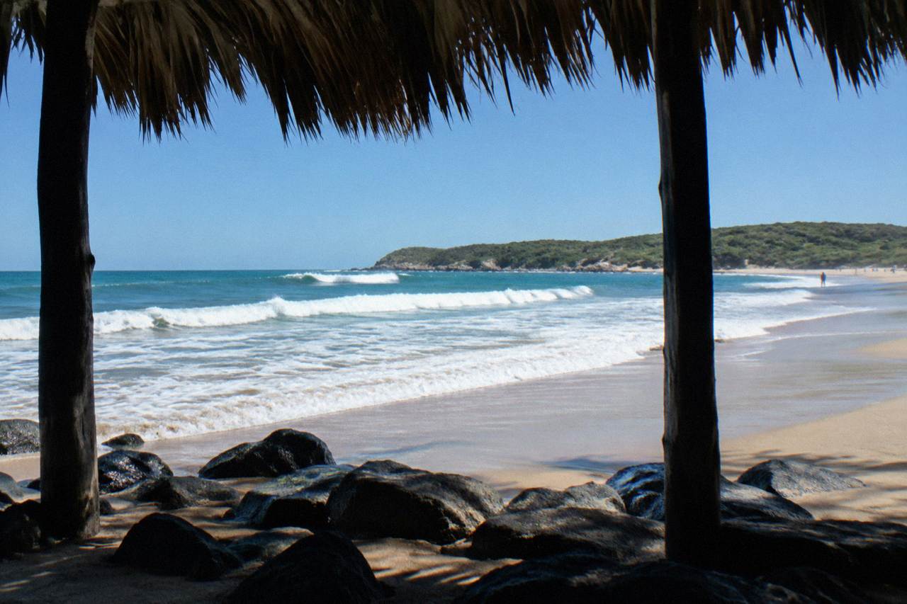
There is no beach in Oaxaca City. The city sits inland in the Valles Centrales at about 1,550 m. The Pacific coast towns of Puerto Escondido, Mazunte and Huatulco are extensions: Puerto Escondido is about a 165-minute drive on the new highway, or a short flight from Oaxaca's Xoxocotlán airport.
Oaxaca City confuses first-time searchers more than almost any other Mexican destination, because the word "Oaxaca" names both a state with a long Pacific shoreline and the inland highland city that almost everyone actually visits. The city itself, Oaxaca de Juárez, sits in the Valles Centrales at about 1,550 m, roughly 200 road kilometres from the nearest sand. The city or coast question has its own deeper comparison if you are still deciding.
Is There A Beach In Oaxaca City?
No, there is no beach in Oaxaca City, and there is no sea, port or navigable river anywhere near it. Oaxaca de Juárez is an inland highland city in the Valles Centrales at about 1,550 m of altitude, roughly 190 road kilometres from Puerto Escondido on the Pacific coast. The beach towns belong to the state of Oaxaca, not to the city, and they are treated on this site as long extensions, never as local day trips.
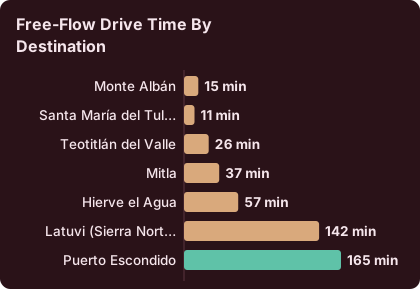
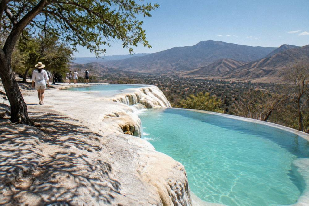
That distinction shapes every planning decision on this page. The city's own attractions are valley attractions: the Zócalo, Santo Domingo de Guzmán, the Andador Macedonio Alcalá, the markets, Monte Albán about 15 minutes away by road, Mitla about 37, Hierve el Agua about 57. None of these involves sand or surf, and the closest water feature the valley offers is the petrified waterfalls and pools at Hierve el Agua, which the tour listings on this site describe in exactly those terms.
The state of Oaxaca, by contrast, has a Pacific shoreline, and the names that come up in every search are Puerto Escondido, Mazunte, Zipolite, Huatulco and San José del Pacífico in the mountains on the way down. Those places sit at the end of a serious mountain road or a short flight. Treating them as if they were suburban beaches is the single most common planning mistake for this destination, and it distorts itineraries that would otherwise work well.
For a full first visit, the question is usually not "beach or no beach" but "how many of my days belong to the valleys and how many can I carve out for the coast". The how many days in Oaxaca guide works through that arithmetic for trips of different lengths.
| Destination | Road distance from the Zócalo | Free-flow drive time | Status on this site |
|---|---|---|---|
| Monte Albán | 8.7 km | about 15 min | Local half-day |
| Santa María del Tule | 10.2 km | about 11 min | Local half-day |
| Teotitlán del Valle | 29.2 km | about 26 min | Local half-day |
| Mitla | 44.6 km | about 37 min | Valley day trip |
| Hierve el Agua | 67.1 km | about 57 min | Valley day trip |
| Latuvi (Sierra Norte) | about 2 hours by road | about 142 min | Mountain extension |
| Puerto Escondido | 190.1 km | about 165 min | Coast extension |
The drive times above are derived from routing on OpenStreetMap roads in free-flow conditions, so they are "about" figures rather than official ones, and real traffic on mountain roads is slower. Even so, the gap is stark: Hierve el Agua, the far end of a normal valley day trip, is barely a third of the way to the sea.
How Far Is The Pacific Coast From Oaxaca City?
Puerto Escondido is 190.1 km from the Zócalo by road, about 165 minutes in free-flow conditions on the new highway, which makes it the one coast figure this site can state with confidence. Prior guides describe the same Barranca Larga to Ventanilla route as taking roughly 2.5 to 3.5 hours depending on conditions and vehicle. The other coast towns, Mazunte and Huatulco, sit beyond or beside that corridor and add their own travel time on top.
The new highway changed the psychology of this trip. Before it, the road to Puerto Escondido was a full-day mountain crossing; at about 165 minutes of free-flow driving it is now a plausible morning transfer, and the Puerto Escondido transfer guide territory of San José del Pacífico sits in the mountains along the way as a possible overnight break. That said, the figure is a derived routing number, not an official schedule, and mountain weather, cargo traffic and the occasional road blockade by teachers' unions, a standing risk in Oaxaca that can disrupt road and airport access, can all stretch it.
There is also the air option. Oaxaca's own airport is Xoxocotlán International, operated by ASUR, with normal operating hours of 06:00 to 20:00, and domestic flights connect the city to the coast without the drive at all. The flights to Oaxaca and Oaxaca airport guides cover the flying side, and the ADO bus guide covers scheduled coach services, whose fares and timetables change often enough that this site prints no numbers for them.
Booking transport and valley tours before arrival is where most of the planning value sits, because the good valley day trips fill first and the coast transfers are easiest to lock in once your dates are fixed.
Which Oaxaca Coast Town Suits Your Trip?
The honest answer is that this site's sources attach figures to Puerto Escondido and to almost nothing else on the coast, so any ranking of coast towns against each other would be invented. Puerto Escondido is the anchor: about 190 km and 165 minutes by the new highway, or a short flight from Xoxocotlán. Mazunte, Zipolite and Huatulco are further extensions along the same shoreline and need their own travel budget on top.
What can be said with confidence is structural. Each coast town is an extension from the city, and every product this site lists for the coast departs from Oaxaca City, never from the sand. If your trip is short, one coast base is the realistic ceiling: fly down, or drive the highway with a stop in the mountains, stay two or three nights, and return. If your trip is a week or more, a split of roughly two thirds valleys and one third coast is the pattern the geography rewards, and the Oaxaca in a week itinerary shows what that split looks like day by day.
Choosing between the towns is a matter of what you want from the shore, and for that the safest guidance is what each place is booked as rather than what any writer remembers. The dedicated pages on this site carry the detail: the Puerto Escondido route comparison frames the city-versus-coast decision, and the weather chapter below tells you what the months actually do, which matters more on the Pacific side than in the valley.
For travellers whose real goal is "water and sunshine without a long transfer", the valley has its own answer, and it is the one most searchers overlook.
Is Hierve El Agua The Valley's Answer To The Beach?
In practical terms, yes: Hierve el Agua is the water destination that actually fits a day trip from Oaxaca City, about 57 minutes by road from the Zócalo, and the tour listings on this site describe petrified waterfalls and pools at the site. It is a mineral-spring mountain setting at altitude, not a beach, but it is the only swim-adjacent stop reachable inside a normal valley day.
The site's tour list carries more Hierve el Agua options than for any other single destination in the valley, from half-day versions to full loops that add Mitla, the Tule tree, rug workshops in Teotitlán del Valle and a mezcal distillery. One stands out for the way it bundles the whole eastern valley into a single day: the Check availability link sits beside this site's Hierve el Agua day trip guide, which explains the route, the timing and what the drive involves.
What Is The Weather Like On The Way To The Oaxaca Coast?
The city's own climate table, from SMN station 20079 normals for 1991 to 2020, shows a dry season from November to April and a rainy season from May to October with its peak from June to September: June averages 188.3 mm of rain against January's 2.4 mm. April carries the highest mean daily high at 34.9 C and January the lowest mean nightly low at 10.3 C. The Pacific side follows the same broad rhythm with its own coastal character.
Those are valley figures, and the drive to the coast crosses mountains before it descends, so the weather you meet on the transfer can be three climates in one morning. Everything else covered here is indexed on Oaxaca Travel Guide.
| Month | Mean daily high C | Mean nightly low C | Rain mm |
|---|---|---|---|
| Jan | 28.9 | 10.3 | 2.4 |
| Feb | 31.1 | 11.6 | 4.6 |
| Mar | 33.3 | 13.6 | 17.6 |
| Apr | 34.9 | 15.8 | 47.3 |
| May | 33.8 | 16.7 | 97.9 |
| Jun | 30.9 | 16.7 | 188.3 |
| Jul | 30.1 | 15.9 | 118.6 |
| Aug | 30.0 | 15.9 | 131.8 |
| Sep | 29.1 | 16.1 | 163.6 |
| Oct | 29.3 | 14.5 | 63.1 |
| Nov | 29.0 | 12.3 | 9.1 |
| Dec | 28.9 | 11.0 | 9.0 |
The full monthly breakdown, including rain-day counts, sits in the Oaxaca weather by month guide, and the best time to visit Oaxaca page adds the festival calendar on top, since Guelaguetza in July and Día de Muertos around the end of October and start of November pull accommodation tight regardless of the rain.
How Do You Get From Oaxaca City To The Coast?
There are three realistic modes: your own car or a transfer on the new highway, about 165 minutes free-flow to Puerto Escondido; a domestic flight from Xoxocotlán International, which ASUR operates with hours of 06:00 to 20:00; or a scheduled coach service, whose fares and times this site does not print. Ride-hailing does not serve the airport, per secondary reporting, so airport transfers run through authorised operators.
For the road option, the practical choice is between a private transfer and building the drive into a rented car itinerary, and every coast product on this site is a city-departure product, as the geography demands. A private transfer suits families and anyone with surfboards or tight flight connections; the shared-shuttle trade-off is flexibility against price. Neither departs from the coast back up as a day excursion, because the geography does not support one.
If you are flying in from outside Mexico first, the usual chain is an international arrival into Mexico City followed by the short hop to Oaxaca, and the Mexico City to Oaxaca guide compares the flight, bus and drive options for that leg. Once in the city, the getting around Oaxaca page covers taxis and ride-hailing for the parts of the trip that stay in the valley.
Can You Combine The Coast And The Valleys In One Trip?
Yes, and it is the pattern the geography rewards: keep the valley as your base for Monte Albán, the craft villages, the markets and the food experiences, then carve out two to four nights for one coast town at the end. With about 165 minutes of driving or a short flight each way, a 10-day trip comfortably holds five or six valley days, a mountain stop at San José del Pacífico if you drive, and three nights on the shore.
The mistake to avoid is interleaving: valley, coast, valley again. Every crossing of the mountains costs the better part of a day in each direction, so the coast works best as a block at the start or, far more commonly, the end of the stay. Food travellers should also weigh what they give up: the cooking classes, market tours and mezcal tastings that define a city stay are valley products, and moving to the coast early means leaving them behind.
| Trip length | Valley base (nights) | Coast block (nights) | Notes |
|---|---|---|---|
| 7 nights | 5 | 2 | Fly one way, drive or fly back |
| 10 nights | 6 to 7 | 3 to 4 | Room for San José del Pacífico stop by road |
| 12+ nights | 8 | 4 | Add Sierra Norte or a second coast town |
For the valley days themselves, the things to do in Oaxaca hub is the full index.
Is The Oaxaca Coast Drive Safe?
The advisory picture: the US State Department lists Oaxaca state at Level 2, Exercise Increased Caution, with no travel restrictions for its personnel to Oaxaca City, Monte Albán, Puerto Escondido or Huatulco, and restrictions confined to the Isthmus region. The UK FCDO advises against all but essential travel to parts of Mexico but does not name Oaxaca on its main page. Canada advises a high degree of caution in Mexico overall.
The standing practical risk on the mountain highway is not crime but disruption: teachers' union blockades periodically close roads and airport access in Oaxaca, and while they are usually resolved within hours or days, they can strand a tight itinerary. Build a slack day around any coast transfer if your flights home are inflexible, and check road conditions on the morning of the drive. The is Oaxaca safe page carries the advisory wording in full.
None of this makes the coast drive unusual for Mexico; it makes it a mountain road that deserves the same respect as any other, driven in daylight where possible.
What Does A Valley-First Itinerary Actually Look Like?
A valley-first plan spends its first days on the Zócalo, Santo Domingo, the Andador Macedonio Alcalá and the markets, then runs one Monte Albán half day, one eastern-valley loop to Hierve el Agua, Mitla and Tule, and one craft-village day among Teotitlán del Valle, San Martín Tilcajete and San Bartolo Coyotepec, before the coast block at the end. The INAH sites on that route charge 105 MXN for nationals and 210 MXN for foreigners at Category I.
| INAH site | Category | Nationals MXN | Foreigners MXN | Hours |
|---|---|---|---|---|
| Monte Albán | I | 105 | 210 | Mon to Sun 08:00 to 17:00, last access 16:00 |
| Mitla | I | 105 | 210 | Mon to Sun 08:00 to 17:00, last access 16:30 |
| Yagul | I | 105 | 210 | Mon to Sun 08:00 to 17:00, last access 16:00 |
| Dainzú | III | 80 | 145 | Mon to Sun 08:00 to 17:00, last access 16:30 |
| Lambityeco | III | 80 | 145 | Mon to Sun 08:00 to 17:00, last access 16:30 |
| Zaachila | III | 80 | 145 | Thu to Sun 10:00 to 16:00 |
Zaachila's Thursday-to-Sunday window is the trap in that table: it is the one valley site with a restricted week, so a craft-village day that wants Zaachila has to fall Thursday through Sunday. The Zaachila and Thursday market page builds around exactly that constraint.
The 2025 visitor counts from the state tourism indicators show where the crowds actually concentrate: Monte Albán recorded 416,675 visitors against Mitla's 104,428, Yagul's 10,185, Lambityeco's 5,545 and Zaachila's 4,229. The city itself logged 1,324,332 arrivals across the year, of which 1,111,799 were national and 212,533 foreign, with an average stay of 2.00 nights. Short stays are the norm, which is exactly why the coast extension has to be planned rather than hoped for.
With the valley block and the coast block both shaped, the remaining decisions are mechanical: where to base in the city, covered by the where to stay in Oaxaca guide, and what the whole trip costs, covered by the Oaxaca travel costs and budget page.
Common Questions About Oaxaca Beaches
Is There A Beach In Oaxaca City?
No. Oaxaca de Juárez is an inland highland city in the Valles Centrales at about 1,550 m, with no sea, port or navigable river.
How Far Is Puerto Escondido From Oaxaca City?
About 190.1 km and 165 minutes of free-flow driving on the new highway. Prior guides describe the same route as roughly 2.5 to 3.5 hours in real conditions. A domestic flight from Xoxocotlán International is the alternative.
Can You Do A Beach Day Trip From Oaxaca City?
Not realistically. With about 165 minutes of driving each way on mountain roads, a same-day return leaves almost no time on the sand. The coast works as an extension block of two or more nights, or as a flight-hop transfer.
What Is The Closest Water Destination To Oaxaca City?
Hierve el Agua, about 57 minutes by road from the Zócalo, is the valley's own water stop, with petrified waterfalls and pools as the tour listings describe it. It is a mountain mineral-spring site at altitude, not a beach.
When Should You Add The Coast To An Oaxaca Trip?
The dry season, November to April, is when the city's rain totals run lowest, from 2.4 mm in January to 47.3 mm in April, and the mountain highway is least exposed to heavy rain. The rainy season peaks June to September, with 188.3 mm in June alone on the city's 1991 to 2020 normals.
Is The Drive From Oaxaca City To The Coast Safe?
The US State Department lists Oaxaca state at Level 2, Exercise Increased Caution, with no restrictions for its personnel to Puerto Escondido or Huatulco; the UK FCDO does not name Oaxaca on its main page. The standing practical risk is sporadic road blockades by teachers' unions, which can close roads and airport access for hours or days.
The short version: Oaxaca City has no beach and does not need one to justify its stay, but the Pacific shore is close enough, at about 165 minutes of highway or one short flight, to belong at the end of any trip longer than a week. Plan the valleys first, block the coast last, and let the mountain road be the bridge rather than the daily commute.