San José Del Pacífico: Mushroom Village On The Coast Road
San José del Pacífico sits on the mountain road that links Oaxaca City, an inland highland capital at about 1,550 m, to the Pacific coast of the state of Oaxaca.
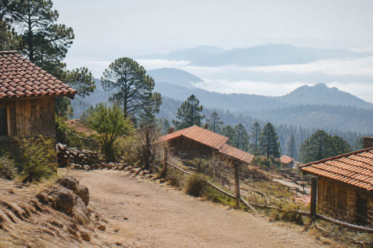
San José del Pacífico is a stop on the long mountain road between Oaxaca City and the Pacific coast, roughly on the way to Puerto Escondido, which the derived routing puts at about 190 km and about 165 minutes of free-flow driving from the Zócalo. It is a far extension of a trip to Oaxaca, not a local day trip, and the mountain road is slower than the raw figures suggest.
San José del Pacífico belongs to the Pacific side of the state of Oaxaca, reached by the mountain road that drops out of the Valles Centrales toward the coast. Oaxaca City itself is an inland highland city at about 1,550 m, with no sea and no beach; the coast, and every stop on the road to it, is a long extension of a city trip rather than a quick outing.
Where Is San José Del Pacífico Relative To Oaxaca City?
San José del Pacífico sits on the mountain road that links Oaxaca City to the Pacific coast of the state, on the corridor toward Puerto Escondido, which the derived routing places at about 190 km from the Zócalo. Oaxaca City is inland, in the Valles Centrales at about 1,550 m, and the coast is a far extension of a city stay, never a local excursion. The village is spelled with the diacritics shown here, and the site's own coverage treats it alongside Puerto Escondido, Mazunte and Huatulco as part of the long coast road story rather than the valley circuit of Monte Albán, Mitla and the craft towns.
That distinction drives everything on this page. The valley destinations the city is famous for, from Monte Albán and the ruins circuit to the Tlacolula Valley, sit within an hour or so of the centre. The coast road is a different proposition: a single long descent through the mountains, usually planned as part of a coast itinerary or a slow loop rather than a there-and-back day. Readers weighing the two should also see the site's comparison piece on choosing Oaxaca City or the coast.
For context on scale, the derived free-flow figures from the Zócalo put Latuvi in the Sierra Norte at about 142 minutes and Puerto Escondido at about 165 minutes, and those are the two longest journeys in the site's table. Real traffic, weather and mountain curves make actual travel slower than any free-flow figure.
How Long Is The Drive From Oaxaca To San José Del Pacífico And The Coast?
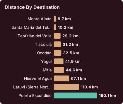
The derived routing gives about 190 km and about 165 minutes of free-flow driving from the Zócalo in Oaxaca City to Puerto Escondido on the new highway, and San José del Pacífico lies along that mountain corridor at an intermediate point between the city and the coast. Every figure in this table is a derived, free-flow estimate rather than an official driving time, and mountain roads, rain and traffic all add time in practice. The site's guidance is to treat these numbers as floor values and to round up when planning a day.
Here is the full derived drive-time table the site carries, measured from the Zócalo:
| Destination | Distance | Free-flow time from the Zócalo |
|---|---|---|
| Monte Albán | 8.7 km | about 15 min |
| Santa María del Tule | 10.2 km | about 11 min |
| Teotitlán del Valle | 29.2 km | 26 min |
| Tlacolula | 31.2 km | about 25 min |
| Ocotlán | 32.5 km | about 37 min |
| Yagul | 41.9 km | about 38 min |
| Mitla | 44.6 km | about 37 min |
| Hierve el Agua | 67.1 km | about 57 min |
| Latuvi (Sierra Norte) | 110.4 km | about 142 min |
| Puerto Escondido | 190.1 km | about 165 min |
The pattern is clear: everything through Mitla and Hierve el Agua is a valley trip measured in tens of minutes, and everything beyond is measured in hours. Straight-line context from the same data puts Mitla about 42 km out, Hierve el Agua about 52 km and Zaachila about 12 km, which underlines how much of the 190 km to the coast is mountain road rather than valley floor.
Planning implication: a realistic schedule treats the coast road as at least a two-day arc, with the night either on the road or on the coast. Readers building a full week can slot it into the site's one-week Oaxaca itinerary, which already separates valley days from the coast extension.
What Is The Weather Like On The Oaxaca Coast Road Through The Year?
The SMN station normals for Oaxaca City, covering 1991 to 2020, show a dry season from November to April with monthly rainfall under 20 mm from November to March, and a rainy season from May to October with a peak between June and September; June averages 188.3 mm of rain and September 163.6 mm. The mountain road between the city and the coast sits under this same seasonal pattern, and rain is the single biggest variable in travel times on it.
| Month | Mean daily high C | Mean nightly low C | Rain mm |
|---|---|---|---|
| Jan | 28.9 | 10.3 | 2.4 |
| Feb | 31.1 | 11.6 | 4.6 |
| Mar | 33.3 | 13.6 | 17.6 |
| Apr | 34.9 | 15.8 | 47.3 |
| May | 33.8 | 16.7 | 97.9 |
| Jun | 30.9 | 16.7 | 188.3 |
| Jul | 30.1 | 15.9 | 118.6 |
| Aug | 30.0 | 15.9 | 131.8 |
| Sep | 29.1 | 16.1 | 163.6 |
| Oct | 29.3 | 14.5 | 63.1 |
| Nov | 29.0 | 12.3 | 9.1 |
| Dec | 28.9 | 11.0 | 9.0 |
Two readings matter for the coast road. One is rainfall, because the June to September peak brings the monthly totals above 100 mm and the number of days with rain above 19 per month in June, July and August. The other is the temperature spread: April has the highest mean daily high at 34.9 C in the city, while December and January bring the lowest mean nightly lows, at 11.0 C and 10.3 C, and the mountains between the city and the coast are cooler than the city floor at either end of the year.
The rain-day counts from the same normals tell the same story in a different way:
| Period | Average days with rain per month |
|---|---|
| Nov to Feb | 1.1 to 3.5 |
| Mar to Apr | 4.1 to 7.6 |
| May | 13.7 |
| Jun to Sep | 19.9 to 21.4 |
| Oct | 12.0 |
None of this ranks months as better or worse; it simply states what the table says. A traveller who needs certainty about dry pavement will read the November to March rows one way, and a traveller planning around Guelaguetza in July, when the city fills for the Lunes del Cerro, will read the July row another.
Can You Visit San José Del Pacífico From Oaxaca Without Driving Yourself?
The transport picture for this route is limited: the site's data confirms that ADO operates the Oaxaca to Puerto Escondido corridor from its official site at ado.com.mx, and that coastal pages on this site carry only city-departure products, so a booked tour or a bus ticket from Oaxaca City are the two sourced ways to cover the road without a car of your own.
What can be stated plainly is the structure: the city is the departure hub, the coast is the destination, and everything in between, San José del Pacífico included, is a stop on that axis. More of these guides are collected on Oaxaca Travel Guide.
There is a second, simpler answer that many travellers arrive at: split the trip. Spend the valley days on bookable departures from the city, and reserve the coast road for either a bus ride through or a rental driven across the mountains. The site's tour list supports the first half well. The related pick on this page is the Hierve el Agua half-day trip from Oaxaca City, a small-group run into the Tlacolula Valley, one of several valley loops that need no car at all: Check availability. Its listing carries the current price, rating and schedule.
For readers comparing the coastal extensions against each other, the site carries full pages on the Oaxaca to Puerto Escondido run and on Oaxaca to Huatulco, and a wider roundup on Oaxaca's beaches. San José del Pacífico belongs inside that set as a road stop, not a destination with its own dedicated city-departure product on this tour list.
Is The Oaxaca To San José Del Pacífico Road Safe To Travel?
The standing advisory picture is this: the UK FCDO advises against all but essential travel to parts of Mexico and does not name Oaxaca on its main page; Canada advises a high degree of caution in Mexico with regional advisories; and the US State Department lists Oaxaca state at Level 2, exercise increased caution, with restrictions for its own staff only in the Isthmus region. Separately, road blockades by teachers' unions are a standing risk in Oaxaca that can disrupt road and airport access without much notice. None of these advisories names the city-to-coast mountain road specifically.
That last point deserves its own paragraph. This is a standing pattern, not a dated event, and the page deliberately gives it no date.
The mountain road itself adds ordinary driving hazards: sustained grades, curves, and in the June to September rainy season, the rain totals already tabulated above. Anyone driving it should plan daylight travel, since the free-flow figures already understate real times and darkness compounds every delay. The site's wider advisory coverage, including the comparison piece on whether Oaxaca is safe, carries the fuller wording.
What Should You Pack For The Oaxaca Mountain Road To The Coast?
Pack for two climates in one day: the dry-season city at about 1,550 m, where mean nightly lows run 10.3 C in January and 11.0 C in December, and the Pacific side at the end of the road, in a state whose coastline faces the Pacific; layers, rain gear for the May to October season, and sturdy shoes for stops along the mountain corridor cover what the climate table implies. The one sourced seasonal fact that should shape the bag is rainfall: 188.3 mm in June against 2.4 mm in January is a spread no single jacket handles both ways.
A short list, drawn only from the climate normals and the road facts already stated:
- Warm layer for evenings in Oaxaca City, where December and January mean nightly lows sit near 10 C.
- Rain shell from May to October, when monthly rainfall runs 63.1 mm or more in every month of that window.
- Sun protection for April, when the mean daily high in the city reaches 34.9 C.
- Daylight planning on the drive itself, since the about-165-minute free-flow figure to Puerto Escondido is a floor, not a forecast.
Nothing on this list is exotic, and that is the point: the mountain road punishes bad timing more than bad gear. Readers wanting the fuller checklist can read the site's what to pack for Oaxaca guide, and those deciding how many days to allow overall should start from how many days in Oaxaca.
How Does San José Del Pacífico Fit Into A Longer Oaxaca Trip?
The workable shape is a valley-first, coast-second arc: use Oaxaca City as a base for the short derived drives, Monte Albán at about 15 minutes, Tule at about 11, Teotitlán del Valle at about 26 and Hierve el Agua at about 57, then leave the valley once and descend the mountain road toward Puerto Escondido at about 165 minutes, with San José del Pacífico as the stopping point on the way.
Trying to visit the village and return to the city in one day turns about five hours of pure driving into the whole trip. The arithmetic is the argument.
Set against the valley options, the contrast is stark and the site's day-trip pages make it easy to build the city half of the arc: Teotitlán del Valle, San Bartolo Coyotepec black pottery, San Martín Tilcajete alebrijes and the Tlacolula Sunday market are all inside the under-40-minute band. The Sierra Norte is the one inland exception on the time table, with Latuvi at about 142 minutes, and travellers who love mountains can read the Sierra Norte and Pueblos Mancomunados page as the highland alternative to the coast road.
The bookable side of the valley half is deep, and the trio of picks placed through this page is a fair cross-section: a Hierve el Agua valley loop, a city culture and history walk, and a market-anchored cooking class. Each departs from Oaxaca City, each covers ground the coast road does not touch, and none of them competes with the mountain drive for a day.
What Do The Bookable Valley Trips Look Like Next To The Coast Road?
Every product the site carries for this region departs from Oaxaca City or its valley, and none of them starts on the coast or on the mountain road, so the practical pattern is simple: book valley tours for valley days, and keep the San José del Pacífico corridor for the drive or the bus. The three tours in the picks band below this section are the ones this page carries as its featured set, and their listings hold the only current prices, ratings and durations worth quoting. The tour list covers ten kinds in total, from archaeology and food walks to mezcal tastings and craft workshops, all city-departure.
The structural comparison:
| Option | Direction from Oaxaca City | Car needed? |
|---|---|---|
| Monte Albán half-day tours | West, about 15 min | No, tour transport |
| Hierve el Agua valley loops | East, about 57 min | No, tour transport |
| City walking and food tours | Within the centre | No |
| Cooking classes with market visits | Within the centre | No |
| Sierra Norte hikes | North, about 142 min to Latuvi | Tour transport or own vehicle |
| San José del Pacífico and the coast | Southwest, on the road toward Puerto Escondido, about 165 min free-flow | Own vehicle or bus |
That last row is the whole page in one line: everything above it is a same-day proposition with a booking button, and the last row is a journey. Readers who want the coast without the drive should read the site's flights to Oaxaca and airport pages, since a short flight to the coast is the alternative the region actually offers, and the site's Oaxaca map page puts all of these distances on one frame.
Common Questions About The Oaxaca To San José Del Pacífico Trip
How Far Is San José Del Pacífico From Oaxaca City?
The site's derived figures cover the corridor it sits on: about 190 km and about 165 minutes of free-flow driving from the Zócalo to Puerto Escondido on the new highway, with San José del Pacífico at an intermediate point on the mountain road. Real mountain driving is slower than the free-flow figure, so plan on more, not less.
Is San José Del Pacífico A Day Trip From Oaxaca City?
Not in any comfortable sense. The village lies on the long road toward the Pacific coast, and the site classifies all coastal stops, including San José del Pacífico, as far extensions of a city stay. The valley day trips, from Monte Albán at about 15 minutes to Hierve el Agua at about 57, are the same-day options.
When Is The Rainy Season On The Oaxaca Coast Road?
The SMN station normals for Oaxaca City put the rainy season from May to October, with a peak between June and September; June averages 188.3 mm of rain and September 163.6 mm. The dry season runs November to April, with November through March each under 20 mm.
Can You Take A Bus From Oaxaca City Toward San José Del Pacífico And The Coast?
ADO operates the Oaxaca to Puerto Escondido corridor, and its official site at ado.com.mx is where schedules and fares are sold.
Is The Road From Oaxaca City To The Pacific Coast Safe?
The standing advisories do not single it out: the UK FCDO does not name Oaxaca on its main page, Canada advises a high degree of caution in Mexico overall, and the US State Department lists Oaxaca state at Level 2, exercise increased caution. Road blockades by teachers' unions are a standing risk in Oaxaca that can disrupt road and airport access, so build slack into any timed connection.
What Should You Combine With San José Del Pacífico On An Oaxaca Trip?
Valley days first, then the coast arc. Bookable departures from the city cover Monte Albán, the Tlacolula Valley and Hierve el Agua, while the coast road, and stops like San José del Pacífico along it, work best as the single long leg of a trip that continues to Puerto Escondido, Mazunte or Huatulco.
The short version of this whole page: treat San José del Pacífico as the mountain-road chapter of a coast itinerary, give the corridor a full day of your own, keep the valley's short derived drives and bookable city departures for the days before it, and read the rainfall and advisory facts above before choosing the month.