Oaxaca To Huatulco: Bus, Flight And Road
Oaxaca City sits inland in the Valles Centrales at about 1,550 m; Huatulco is a Pacific coast resort several hours away by road, reachable by bus, flight or driving.
This guide compares the options using distances, seasons and site facts.
Oaxaca City, the capital of the state of Oaxaca in Mexico, is an inland highland city in the Valles Centrales at about 1,550 m; Huatulco is a Pacific coast resort reachable by a long road descent from those valleys, by bus, or by air with a connection. The road down from the highlands to the coast crosses real mountain terrain, so every option on this page is a serious journey rather than a short hop, and the state tourism authority counted 1,324,332 visitor arrivals in the city across 2025, many of whom pair the highlands with a coast extension.
How Far Is Oaxaca City From Huatulco?
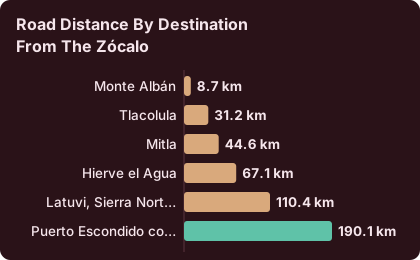
Huatulco sits on the Pacific coast well beyond the reach of a valley day trip from Oaxaca City, and the road figures stop at Puerto Escondido, about 190.1 km and about 165 minutes of free-flow driving from the Zócalo on the newer highway, with Huatulco reached by continuing along the coast road from there. The card gives no separate Huatulco distance, and the earlier two-lane routes took far longer than the figures above, so treat the whole run as a full day of mountain and coastal driving rather than a commute.
For scale, compare the valley destinations that really are day trips: Monte Albán is about 8.7 km from the Zócalo, Mitla about 44.6 km, and Hierve el Agua about 67.1 km. The coast is a different category of journey altogether, which is why this site files Huatulco, Puerto Escondido and Mazunte as long extensions and never as local outings. Readers weighing coast options can start with the Oaxaca to Puerto Escondido guide, which covers the nearest major beach town and the new highway that changed those drive times.
| Destination from the Zócalo | Road distance | Free-flow drive time |
|---|---|---|
| Monte Albán | 8.7 km | about 15 min |
| Tlacolula | 31.2 km | about 25 min |
| Mitla | 44.6 km | about 37 min |
| Hierve el Agua | 67.1 km | about 57 min |
| Latuvi, Sierra Norte | 110.4 km | about 142 min |
| Puerto Escondido coast | 190.1 km | about 165 min |
These are derived free-flow figures, computed on mapped roads rather than measured as official journey times, and real traffic, checkpoints and mountain gradients make them slower. They are useful for scale: the coast is roughly four times the distance of Hierve el Agua.
What Is The Best Way To Get From Oaxaca To Huatulco?
There is no single best route, because the three options trade time, cost and comfort differently: the road journey covers about 190 km to the coast region before continuing to Huatulco, the bus is booked through the operator's own site at a fare the operator sets, and flying means a connection, since Oaxaca's airport carries no direct Oaxaca City to Huatulco service. The choice usually comes down to how much of the holiday the coast leg deserves, and whether the mountain road is part of the appeal or a cost to be avoided.
The bus is the default for travellers who do not want to drive the mountains themselves. ADO, the main operator, runs service from Oaxaca toward the coast, and its official site is where schedules and fares live; no figure for either appears on this page because the operator sets them and changes them. The ADO bus guide for Oaxaca explains how the terminal system works, and the comparison in fly or take the bus to Oaxaca walks through the same trade-off in the other direction, from Mexico City.
Driving gives the most control and the most exposure to the terrain. The newer highway to the Puerto Escondido region cut the free-flow figure to about 165 minutes to that stretch of coast, though earlier guides put the fuller journey at 2.5 to 3.5 hours depending on conditions and vehicle, and Huatulco adds further coastal distance beyond that. The Oaxaca to San José del Pacífico guide covers the highland leg of that same corridor, where the road climbs through the Sierra Sur before dropping toward the Pacific.
| Option | What the record gives | What to check |
|---|---|---|
| Road drive | About 190 km and about 165 min free-flow to the Puerto Escondido coast region; Huatulco continues from there | Current road conditions and total time |
| Bus | ADO is the main operator; its official site is the source for service to the coast | Departure times and fares |
| Tour with coast leg | Bookable products on this site depart from Oaxaca City only | Itinerary details |
Can You Fly From Oaxaca City To Huatulco?
Flying from Oaxaca City to Huatulco means a connection, because the route list for Oaxaca's Xoxocotlán airport includes Mexico City, Tijuana, Cancún, Monterrey, Guadalajara and several US cities, and no direct service to Huatulco appears in it; a common alternative is to fly into a coast airport and travel overland to Huatulco from there. The airport itself, operated by ASUR, runs normal operations between 06:00 and 20:00, and no runway closures or disruptions have been announced.
The practical reading is that air does not shortcut the coast trip the way it shortcuts Mexico City, where multiple daily flights make the bus vs plane question real. For Huatulco, the overland options stay central to the plan, and the air leg is a routing decision around them. Travellers already weighing air vs road elsewhere in the region can compare notes in the Mexico City to Oaxaca guide and its return leg, Oaxaca to Mexico City.
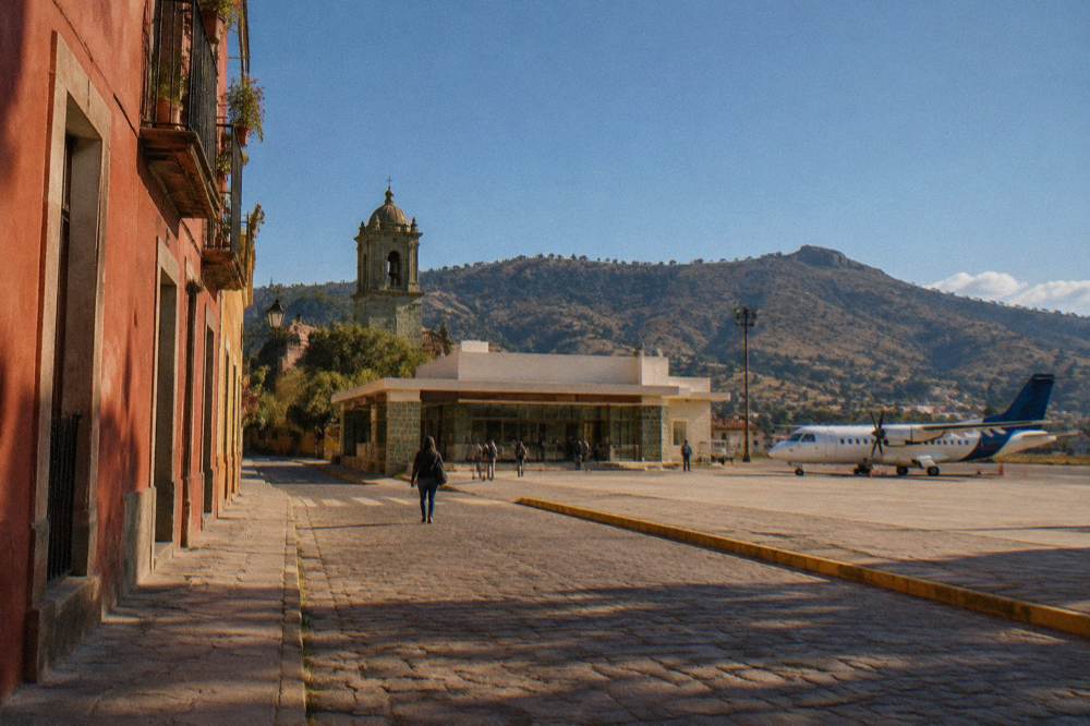
One planning point: ride-hailing and airport shuttle details for Oaxaca's airport are unsourced here, and only authorised transport operates from the terminal, so ground transfers at both ends are best arranged with the operator or the accommodation. No fare figure for any airport transfer appears on this page.
Is The Bus From Oaxaca To Huatulco A Good Option?
The bus is a reasonable option precisely because the road is demanding: ADO operates first-class services from Oaxaca toward the coast, its official site is the single source for schedules and fares, and the trade is a longer seated journey against not driving about 190 km of mountain and coastal highway yourself. No journey time or peso figure for the Oaxaca to Huatulco bus appears on this page, and both are set by the operator.
The seated-class question matters more on this corridor than on the valley runs. The highway climbs out of the Valles Centrales, crosses the Sierra Sur, and descends to the Pacific, so travellers who book should check which class of service the operator runs on the coast route and what it includes. The bus from Puerto Escondido to Oaxaca City covers the sister route from the other direction and the same operator context applies.
Is The Drive From Oaxaca To Huatulco Safe?
The advisory picture for the route does not flag Oaxaca City itself: the US State Department lists Oaxaca state at Level 2, exercise increased caution, with restrictions only in the Isthmus region and none for Oaxaca City, Monte Albán, Puerto Escondido or Huatulco, while the UK and Canadian advisories do not name Oaxaca among areas to avoid. The standing practical risk on Oaxaca roads is different: sporadic blockades by teachers' unions have repeatedly closed highway routes and airport access for short periods, and these can disrupt any coast journey without much notice.
The road-safety question is therefore mostly terrain and timing. Mountain highways, gradients and weather are the everyday hazards, and the rainy season from May to October brings the heaviest rain to the region, with the Oaxaca station normals showing June at 188.3 mm and September at 163.6 mm for the city itself. The advisory wording above is reported as it stands; check the current advisory pages before a long drive. Other pages covering the same trip are gathered on Oaxaca Travel Guide.
| Advisory source | Position covering Oaxaca |
|---|---|
| US State Department | Oaxaca state Level 2, exercise increased caution; no restrictions for Oaxaca City, Monte Albán, Puerto Escondido or Huatulco; restrictions in the Isthmus region |
| UK FCDO | Advises against all but essential travel to parts of Mexico; Oaxaca is not named on the main page |
| Canada | Exercise a high degree of caution in Mexico overall, with regional advisories; Oaxaca not named as an avoid-travel area |
What Is The Weather Difference Between Oaxaca City And The Huatulco Coast?
Oaxaca City sits at about 1,550 m with a dry season from November to April and a rainy season from May to October, while Huatulco lies on the Pacific coast at sea level, so the same day can carry a 10 C night in the city and hot coastal conditions on the beach, and the climate table below gives the city's monthly normals so the highland half of the trip can be planned around real figures. The station normals put January nights at an average low of 10.3 C and April daytime highs at an average 34.9 C in the city.
Packing for both halves of the trip is therefore a two-climate exercise. The what to pack for Oaxaca page expands the highland side of that list.
| Month | Average high C | Average low C | Average rain mm |
|---|---|---|---|
| Jan | 28.9 | 10.3 | 2.4 |
| Mar | 33.3 | 13.6 | 17.6 |
| May | 33.8 | 16.7 | 97.9 |
| Jun | 30.9 | 16.7 | 188.3 |
| Sep | 29.1 | 16.1 | 163.6 |
| Nov | 29.0 | 12.3 | 9.1 |
These are Oaxaca City normals from the SMN station, 1991 to 2020; coastal Huatulco runs on its own seaside pattern, so this page states no Huatulco station figure.
Can You Visit Huatulco As A Day Trip From Oaxaca City?
No, and the site files Huatulco as a long extension rather than a day trip: the road figure to the Puerto Escondido stretch of coast alone is about 190 km and about 165 minutes of free-flow driving, with Huatulco beyond it along the coast, so a same-day return means the better part of a day on mountain roads before any beach time at all. The day trips that genuinely work from the city stay inside the Valles Centrales or the nearer Sierra Norte.
That distinction shapes how the site organizes its day-trip pages. Within easy reach sit Hierve el Agua, Mitla and Tlacolula, Teotitlán del Valle and the craft towns of the valley, while the coast pages, Huatulco included, are planned as overnight extensions with their own accommodation logic. The Oaxaca in a week itinerary shows how a coast leg fits at the end of a highland stay.
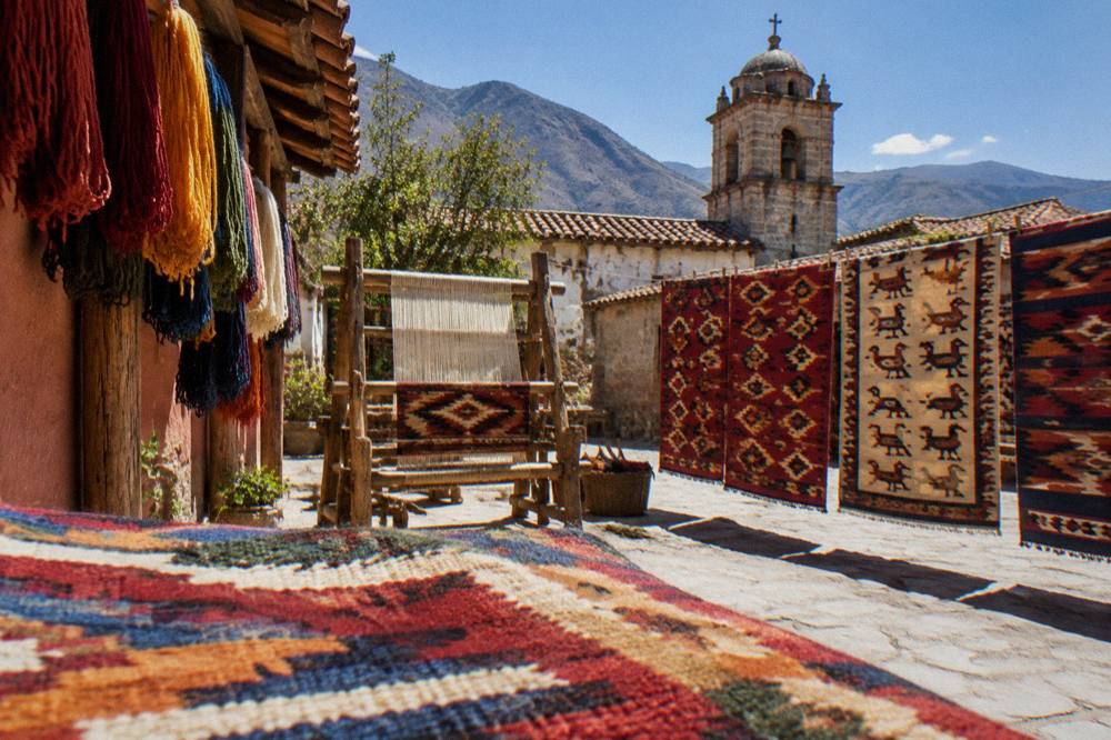
For travellers who want a structured valley day instead of driving themselves, a loop covering Monte Albán with craft villages is one of the strongest options on the tour list: Check availability on the operator's booking page.
What Should You Do In Oaxaca City Before Or After The Coast Leg?
The highland half of the trip carries most of what the destination is known for: Monte Albán recorded 416,675 visitors in 2025 and Mitla 104,428, the Zócalo, Santo Domingo de Guzmán and the Andador Macedonio Alcalá anchor the historic centre, and the markets, mezcal and cooking traditions of the city fill the days before or after a coast extension. The city's own tourism indicators put the average stay at 2.00 nights, so most itineraries add days rather than stretch one.
The museum and garden timings matter for planning. The Museo de las Culturas de Oaxaca is open Tuesday to Saturday only, 10:00 to 16:00, and the Jardín Etnobotánico runs free guided visits Monday to Friday at 10:30, 11:00, 11:30, 12:00 and 17:00, and Saturday from 10:30 to 12:00, with large groups booking two weeks ahead. The Jardín Etnobotánico guide and the Santo Domingo church guide carry the details.
| INAH site near the city route | Hours | Fee, nationals | Fee, foreigners |
|---|---|---|---|
| Monte Albán | Mon to Sun 08:00 to 17:00, last access 16:00 | 105 MXN | 210 MXN |
| Mitla | Mon to Sun 08:00 to 17:00, last access 16:30 | 105 MXN | 210 MXN |
| Yagul | Mon to Sun 08:00 to 17:00, last access 16:00 | 105 MXN | 210 MXN |
| Atzompa | Mon to Sun 08:00 to 16:00, last access 15:00 | not stated on the page | not stated on the page |
| Zaachila | Thu to Sun 10:00 to 16:00 | 80 MXN | 145 MXN |
Food is the other highland anchor. A markets walk with tastings is one of the tour list's strongest city products, and the Oaxaca food tour guide lays out the market landscape, from the 20 de Noviembre to Benito Juárez, that such tours work through.
How Should You Plan The Oaxaca To Huatulco Route Around The Seasons?
The seasonal logic splits cleanly: the dry season from November to April carries the city's lowest rain figures, with January at 2.4 mm and November at 9.1 mm on the station normals, while the rainy season from May to October peaks between June and September, and a coast extension is easiest to plan when the mountain road half of the journey avoids those peak-rain months. The normals give June 188.3 mm and September 163.6 mm for the city, and the coast adds its own Pacific storm exposure on top.
The festival calendar also moves the plan. Guelaguetza fills the city on two Mondays in July each year at the Auditorio Guelaguetza on the Cerro del Fortín, with the 2026 edition's Palco A at 1,632 MXN and Palco B at 1,321 MXN and the C and D sections free, and Día de Muertos centres on the traditional 31 October to 2 November dates. Both periods change accommodation demand in the city, and the best time to visit Oaxaca page works through the trade-offs in full.
| Season in Oaxaca City | Months | Station normals for the city | Planning effect on a Huatulco extension |
|---|---|---|---|
| Dry season | November to April | January rain 2.4 mm; April high 34.9 C | Easiest mountain-road conditions; April heat on the coast |
| Rainy season | May to October | June rain 188.3 mm; September 163.6 mm | Wet roads on the descent; afternoon storms |
| Festival peaks | July; late Oct to early Nov | Guelaguetza two Mondays in July; Día de Muertos 31 Oct to 2 Nov | City demand spikes before or after a coast leg |
Common Questions About Travel From Oaxaca To Huatulco
How Do You Get From Oaxaca To Huatulco?
How Far Is Huatulco From Oaxaca City?
Can You Do Huatulco As A Day Trip From Oaxaca City?
No. The site files Huatulco as a long overnight extension; a same-day return would spend most of the day on mountain roads. Genuine day trips from the city stay in the Valles Centrales or the Sierra Norte.
Is The Road From Oaxaca To Huatulco Safe?
The US advisory lists Oaxaca state at Level 2, exercise increased caution, with no restrictions for Oaxaca City, Puerto Escondido or Huatulco; the UK and Canadian advisories do not name Oaxaca as an avoid area. Sporadic road blockades remain a standing risk, and the mountain highway demands care.
Do You Need A Jacket In Oaxaca City Before Flying To The Huatulco Coast?
Yes for the highland half. January nights average 10.3 C in the city, and December to January are the cooler nights on the station normals, while the coast runs hot, so pack for two climates.